Well I've now recovered enough to move my fingers, slowly and painfully, to tell you about the hike I went on on Saturday.
I received an email from Tim (German post doc at Berkely if you've forgotten) on Thursday that he and a friend of his, Bo, were going on a hike. A lot of people were invited and I figured I would join as well. Can't meet too many people after all. I invited Polly and her boyfriend (who was visiting) but they decided not to come (something about spending time together or something, I dunno).
Well as it happened, It was just Tim, Bo, and myself. Everyone else had bailed, which was really too bad as even one more person may have injected a modicum of sanity into the group, enough to stop what followed.
We met at Charlie's pub and Tim drove us more or less in the direction of the mountains to a point where it seemed good for us to stop (that is, there was parking as near to the mountains as we could get). Bo had been up this particular mountain before, following a dry river bed (snow melt drainage we think, it looks somewhat man made). The pictures that follow (there are many) were taken from my droid camera which performed surprisingly well!

We set out around 10:45 towards the Jura mountains, a ridge that, with the Swiss Alps on the other side, form the valley that CERN, Geneva, and St. Genis (among other places) are in. The highest peak, just left of middle, is the one we wound up nearest. Bo is on the left. He was born in Denmark but has lived in the US for years, to the point where he has no accent. Tim is on the right with the pack.

This hike went pretty much the same way that most of my hikes go: with little regard for direction, trail, distance, or private property. We managed to cross several property lines while avoiding no trespassing signs. This of course does not mean we didn't SEE no trespassing signs, but when we did we chose another spot to cross the property line at where it wasn't readily visible. Always have an alibi.

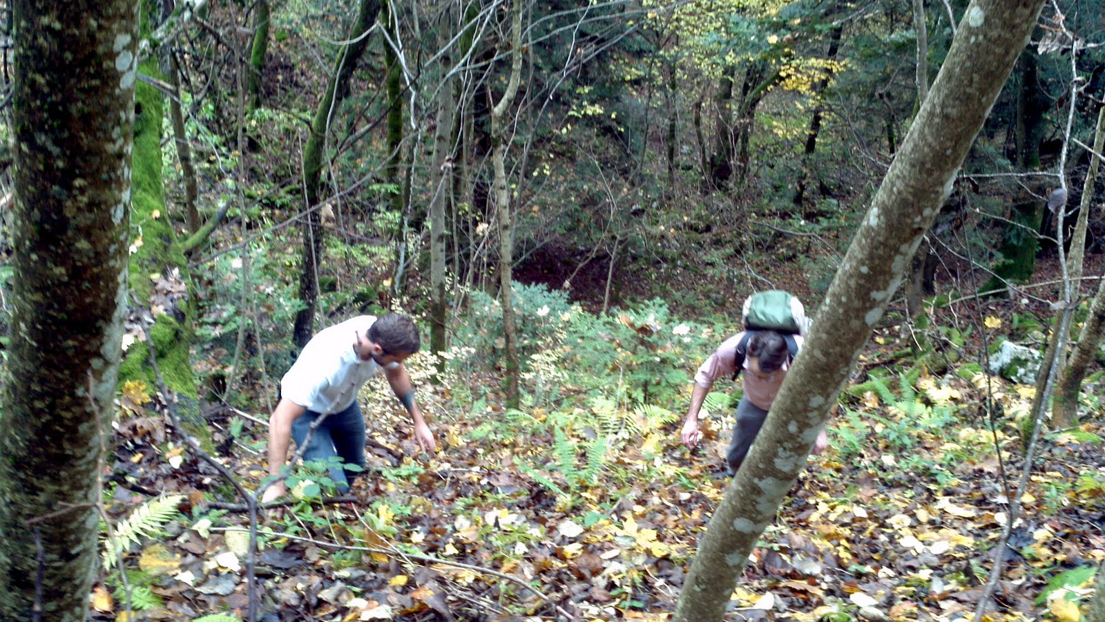
 We got to the trail once we reached the foot of the mountains themselves. Of course, by trail I mean the leaf strewn, rock infested chute you see here. Over all this was the easy part of the hike (save when were were finally on top). Hidden rocks in soft leaves make for tricky footing, especially at a slope better than 30 degrees at the shallowest. I don't mess around when I say we went strait up the mountain.
Of course, the leaves and rocks weren't our only path as we picked our way through quite a pretty forest. Eventually the rocks won out over the leaves and the going got, if not easier, then at least less likely to twist an ankle.

 One of the things that Bo had discovered on his previous trip up this way was a rather immense safe that had obviously been stolen, cut open, and dumped in the woods. At this point we were maybe two miles up a very steep slope. This safe must weigh half a ton. How did it get here? NOBODY KNOWS! At least we didn't know until Bo said that there was a road just up the hill and ruined the mystery. Sadly there was no gold or jewels still inside (we checked).
We continued up to a place with a nice view for lunch. The first stage of the hike was over, but from here it got difficult. Personally I was quite tired by the end (as were Tim and Bo, even if they don't admit it).

Lunch was a communal affair. Both Tim and I had brought food (though Tim had brought more) and the three of us shared a rather delicous lunch of good bread, excellent cheese, amazing apples, and various meat. And a good view.

Continuing up the mountain brought us to ever more rocky terrain, including spectacular shelves of rock. I still maintain it was a kind of granite, but it could have been some very hard limestone derivative. It seemed like fossilized chalk. If anyone knows what limestone's metamorphic equivalent is, let me know. That's probably was this is.

By this point were were past where Bo had come and continuing rather rapidly up very steep terrain. The leaves on the ground were back with a vengeance and very deep, making the going slippery. If you stepped wrong, you slid back at least three feet if you were lucky. Four feet forward, three feet back! Makes for a fun hike. One of the very neat things we came across was a small cave in one of the rock shelves barring our path. It was wet and slippery and at the top of a very steep detour. It was a cave on a mountain. How could we stay away?

 Above the cave was a field of rock, dense trees, and grass. Of course, this is if your definition of a field is tilted by 40 degrees and made slippery. We probably were quite foolish to climb up this way, but going back down and finding another way up the rock face would have required going down hill and, more importantly, back up hill. Besides, that would have been admitting that the mountain could tell us where to go.
 As you can see, it was quite dense going (particularly if you were carrying a backpack like Tim and I).
 Eventually it cleared out and we found our way up to a rather nice area of the woods. One of the strange things about this hike was everywhere we went - and we were literally in the middle of NOWHERE any human had a right to be - we kept finding trees that had obviously been chainsawed. While some were obviously from logging at least a decade ago, some were just little things keeping a path clear. WHAT PATH? We were four miles up a mountain having followed no path and at least 200 feet above the closest road.
Why would anyone cut a path here? We had no idea. Obviously there had been logging. We found not only old, thick stumps but also a road that looked like it hadn't been used save for four wheeling and dirt biking in a long time. It was very welcome after such a steep ascent, so we walked on the flat a little ways just enjoying not going up.
 As we had been climbing, the views got ever more spectacular, especially as the trees cleared. It alternately rained and was foggy (we climbed through the lower cloud layer at one point, which was really cool), but I think my little droid camera did a brilliant job.
Those are the Swiss alps across the valley, Mt. Blanc is unfortunately hidden by clouds. We only got a peek at him, but he absolutely TOWERS over the other mountains around him.

As we neared the top, we came to places were the trees were completely out of view and I could actually get some great shots of the valley below without obstruction.

I'm used to being on mountains, so I'm no stranger to false peaks, but it kept going! We eventually DID see the real peak (it had a marker built on it, so I hope it was the real peak) but it was too much for one day, especially as my hamstring felt like it was pulling away from the bone and my calves hadn't taken such a beating since Philmont (boy scout high adventure hiking camp for those not familiar with it, and I had trained for that one).

Near the top we came across this pit. That is a hole, the camera pointed pretty much strait down. This is the best angle I could get it from. We dropped rocks in there and it was a long, LONG way down in there. A few hundred feet at least. It was fortunately surrounded by barbed wire fencing (WHO BUILT FENCES UP HERE??) so no one would fall in.
 The country up here was unbelievably gorgeous. I left in a lot of pictures that I would have deleted for space (this is already a very long post) because they were worth it. I loved it once we reached above the tree line onto, of all things, cow pastures. The fences were marking property lines (which we disregarded). There was plenty of other... evidence... of cows as well, and I don't mean milk bottles.
 And of course, views into the valley remained spectacular, especially with some neat cloud formations due to wind off the mountain.


 Though exhausted, we decided not to go down the way we had come up. It was far too steep to be done safely. Up had been bad enough, down would have been impossible in places, especially getting above that cave. There was a road that was likely used by whomever owned the cows when they were up here in the summer.
We came across some buildings on occasion, the Chalet de Curson. Anyone familiar with Star Trek: Deep Space Nine will share my join at that name. It is apparently an emergency shelter for those lost in the mountains in winter. We didn't bother going up to it.


The area around here was short grass and moss, with some cool artichoke related plants. Here I am near the Chateau de Curson. Forgive my disheveled appearance and crooked sunglasses, I'm a poor student who lacks hygiene. Also I had just walked up a bloody mountain. I had to look the part.
 We continued on to ever better views of the valley, especially as the sun came out to greet us.


 We came across a cabin, likely used in the summer by the man with the cows (we at least speculated on that). No power but one small solar cell, and it had oil lamps inside (we could only see in the window, even though I did try the door).
 We had climbed from around 500 meters above sea level, which amounted to over 3000 feet according to this sign. All of it at once. The sign at least told us that there were further things to see. Besides, Tim's GPS on his phone (it worked well) told us the road would eventually lead us where we wanted.
Let me just say I'm a home with mountain views and rolling planes. Thought the mountain goats that crossed the road at high speed ahead of us were different. Also neat. Sadly none of the pictures I attempted to take of them worked out.

 You cant see them very well, but on that wicked sheer side of the mountain eight or nine mountain goats were just chilling. Nothing else can walk there, much less move fast enough to catch them. They were safe from the world.

We started our descent in much the same manner we ascended: strait the heck down. Sadly none of these pictures do it justice, but the road we were on was some concrete like pavement that was so steep, even Tim in good hiking boots had some trouble keeping his footing on it. Personally, in my rather beat up running shoes, I slid more than half the time.
 We did get into some color: yellow leaves and red berries make for a pretty autumn landscape.
 When we finally did get down, it was getting dark. We wound up getting back to the old logging road and finding an alternate path to the road that the safe had been dumped from and where we ate lunch. It took some doing, but we managed to (barely) beat nightfall. As we approached St. Genis again, the lights were lit and the valley was a jewel studded plane.
Here again is the mountain we climbed, the peak pretty much in the middle of the photo was the one we got closest to (it was just above the cliff with the mountain goats on it). We're going to try to go back next weekend and get all the way to the top, but this time, having conquered all but the last few hundred feet, we're going to start from as high up as we can drive in order to spend more time up there where it was so beautiful (and the walking at least pleasant).
Thanks for reading my longest, most picture strewn post yet!
Caio!
No comments:
Post a Comment